
Blog Articles
Understanding Remote ID and Applying for a FRIA at Your School
March 3, 2024 — 10 minutes
The advent of drone technology has revolutionized various sectors, including education. Drones offer an interactive way to engage students in STEM (Science, Technology, Engineering, and Mathematics) fields, providing hands-on experience with technology that is shaping the future. However, integrating drones into educational settings comes with challenges, especially regarding safety, privacy, and regulatory compliance. This post aims to address the concerns of school administrators and teachers regarding flying drones at educational institutions, focusing on the concept of Remote Identification (Remote ID) and the establishment of Federal Aviation Administration (FAA)-Recognized Identification Areas (FRIAs).
Understanding Remote ID for Drones
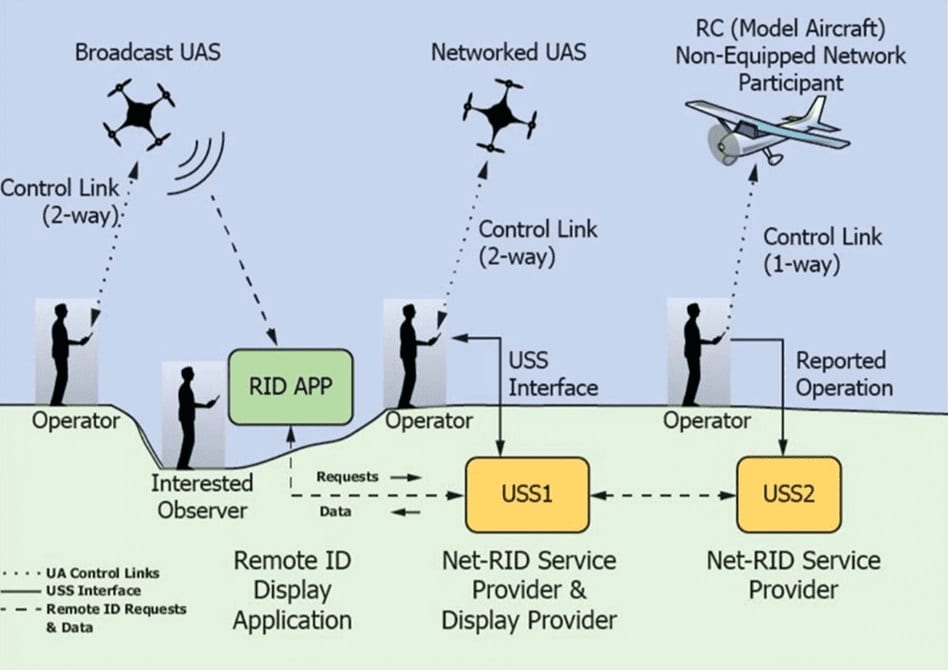
Remote ID acts as a digital license plate for drones, enabling identification of unmanned aircraft flying in the airspace from the ground. As part of the FAA’s efforts to integrate drones safely into the airspace, Remote ID provides critical information such as the drone’s control station location, takeoff location, and identification number. This initiative addresses safety, national security, and law enforcement concerns, facilitating a safer and more responsible use of drone technology.
Remote ID Final Rule Summary and Key Dates
The Remote ID Final Rule establishes the framework and timelines for compliance by manufacturers and operators:
- Manufacturers must comply with the Remote ID specifications starting September 16, 2022, with an 18-month adaptation period.
- Operators have a 30-month period post the manufacturer’s deadline, culminating on September 16, 2023, which extends to March 16, 2024, considering the enforcement extension.
- FRIA Application Submission began in September 2022, allowing certain organizations to operate drones without Remote ID in designated areas.
Remote ID Types and Requirements
Standard Remote ID (SRID): Integrated into the drone and its control station, SRID broadcasts information from takeoff to shutdown, including the drone’s ID, location, altitude, and control station’s location. It must undergo a self-test before takeoff and continuously monitor functionality during flight. SRID drones must be tamper-resistant, incorporate error correction, and comply with transmission standards ensuring compatibility with personal wireless devices.
Broadcast Module Remote ID (MRID): This is an add-on component for drones that do not have built-in Remote ID, broadcasting similar information to SRID. The key differences are that the MRID does not need to be integrated into the drone or control station, and the operator must maintain a visual line of sight with the drone during operation. The serial number pertains to the module rather than the drone.
No Remote ID (NRID): Drones without Remote ID can only operate within FAA-Recognized Identification Areas (FRIA), if the drone remains within visual line of sight.
Remote ID Exemptions Beyond FRIA
While the Federal Aviation Administration (FAA) has implemented Remote Identification (Remote ID) requirements to enhance safety and accountability in the national airspace, there are specific exemptions to these rules beyond FAA-Recognized Identification Areas (FRIAs). These exemptions are designed to accommodate different types of drone operations, ranging from recreational to military and public safety operations. Here’s a closer look at these exemptions:
Recreational Drones Under 250g
- Exemption Criteria: Drones weighing under 250 grams (approximately 0.55 lbs) are exempt from the requirement to be registered with the FAA for recreational use. Consequently, these lightweight drones do not need to comply with Remote ID requirements.
- Considerations: It’s noteworthy that many compact drones, such as the DJI Mini 3 and Autel Nano, have built-in Remote ID capabilities. Once activated, these features cannot be disabled, making these drones compliant regardless of the exemption. This reflects a trend where drone manufacturers integrate Remote ID features by default, anticipating broader regulatory needs and enhancing safety.
Military Drones
- Exemption Scope: Drones operated by the United States military are exempt from Remote ID requirements. This exemption recognizes military drone use’s unique operational needs and security considerations. Such operations are governed by specific regulations and oversight, separate from civilian airspace rules.
Public Safety SecOps
- Operational Flexibility: Public safety entities, such as law enforcement and emergency services, may operate drones without Remote ID in certain security-sensitive operations. This exemption is intended to support operations where Remote ID could compromise operational security or effectiveness.
- Justification Requirement: To avail of this exemption, public safety entities must provide justification to the FAA, outlining why the operation requires an exemption from Remote ID. This process ensures that each exemption is granted based on clear operational needs while maintaining overall airspace safety and security.
The Importance of Remote ID in Educational Settings
Understanding and adhering to Remote ID regulations is paramount for educational institutions looking to incorporate drone technology into their curriculum. Remote ID ensures that drones used in educational activities are operated safely, minimizing risks to both the operators and the surrounding community. It also helps instill a culture of responsibility and regulatory compliance among students, preparing them for future drone technology and aviation endeavors.
Establishing FAA-Recognized Identification Areas (FRIAs)
Schools and educational institutions wishing to operate drones without Remote ID must apply for the establishment of a FRIA. A FRIA is a defined geographic area where drones can be flown without Remote ID, under the condition that they remain within the FRIA boundaries and in visual line of sight of the operator. This provision allows educational institutions to continue using drones that may not be equipped with Remote ID technology under controlled and safe conditions.
Eligibility and Application Process for FRIAs
To be eligible for an FRIA, the FAA must recognize an institution as either a community-based organization (CBO) or an educational institution. The application process involves submitting detailed information about the proposed FRIA, including the physical address, boundaries, and the area’s intended purpose. The FAA assesses applications based on criteria such as the impact on airspace safety and efficiency, proximity to airports and heliports, and the safety and security of people and property on the ground.
When delineating the boundaries of your proposed FRIA, avoid including roads or parking lots within your coordinates. The presence of such areas could raise concerns regarding the safety and security of persons or property on the ground, potentially complicating the approval process. This consideration is vital in demonstrating to the FAA that your FRIA will be established with the utmost regard for safety and regulatory compliance. Additionally, it’s important to note that the application review process by the FAA does not have a fixed timeline. Patience is key, as the review process can vary in duration.
Navigating the Application Process for FRIAs
To ensure a successful application for establishing an FAA-Recognized Identification Area (FRIA) at your school, it’s crucial to understand and meticulously follow the application process. Below, we provide a detailed guide on applying for a FRIA.
Instructions for Applying for a FRIA at your School
Follow these steps to apply for a FRIA through the FAADroneZone website, ensuring you have all the necessary information and documentation ready:
- Access FAADroneZone: Navigate to the FAADroneZone website. If you don’t already have an account, you’ll need to create one. If you have an existing account, simply log in.
- Add a Service: Once logged in, locate the “Add a Service” option on the FAADroneZone Services screen.
- Select FRIA Service: Find and click on “Select FRIA Service,” then proceed by clicking the “Add Service” button.
- Launch FRIA Dashboard: You will be directed to the FRIA dashboard. Here, confirm your profile details to ensure they are accurate and up-to-date.
- Create FRIA Application: Within the FRIA dashboard, you’ll find the option to “Create a FRIA Application.” Click on this to begin the application process.
- Complete and Submit Application: Fill out the FRIA application with all the required information. Ensure that every detail is accurate and complete before submission.
Note: The FAA does not provide an estimated timeline for the review of FRIA applications. The duration of the review process can vary, so it’s essential to apply well before you wish to start your drone operations within the FRIA.
Renewal and Termination of FAA-Recognized Identification Areas (FRIAs)
Establishing FAA-Recognized Identification Areas (FRIAs) has provided a valuable framework for operating drones without Remote ID, under specific conditions. These designated areas support recreational, educational, and community-based drone activities. Understanding the processes for renewing and terminating FRIAs is essential for organizations looking to maintain or establish such areas for drone operations.
Renewal of FRIAs
Approved FRIAs are valid for a period of 48 months (4 years). To ensure continuity in drone operations within these areas, Community-Based Organizations (CBOs) and educational institutions must apply for renewal no less than 120 days before the FRIA’s expiration date. This timeline allows the FAA to review and process renewal applications effectively, ensuring that there is no lapse in FRIA status.
It is important to note that the FAA may deny renewal requests submitted after this 120-day pre-expiration period. Organizations planning to continue their drone operations within an FRIA must be vigilant in tracking their FRIA’s expiration date and submitting their renewal applications in a timely manner.
Termination of FRIAs
The FAA holds the authority to terminate an FRIA for several reasons:
- Safety and Security Risks: If an FRIA poses a risk to aviation safety, national security, homeland security, or public safety, the FAA may opt to terminate its status.
- False or Misleading Information: Submission of false or misleading information during the FRIA application process is also grounds for termination.
Organizations affected by an FRIA termination have the right to petition the FAA to reconsider their decision. This petition must be submitted no later than 30 calendar days after the termination announcement.
In cases where an FRIA expires without renewal, a CBO or educational institution may reapply for the same area. However, such applications will be treated as new, subject to the standard review and approval process. Additionally, organizations can voluntarily request the termination of their FRIA, with the option to re-establish it later if desired.
Locating Existing FAA-Recognized Identification Areas (FRIAs)
For schools interested in integrating drone technology into their curriculum but concerned about the application process for establishing a new FRIA, or those simply looking to understand the landscape of authorized drone operation areas, locating existing FRIAs can be invaluable. The FAA provides resources to help the public, educational institutions, and drone enthusiasts find FRIAs across the United States. Utilizing these resources can offer insights into where drones can be flown without Remote ID, potentially opening up opportunities for collaboration or participation in drone activities within these designated areas.
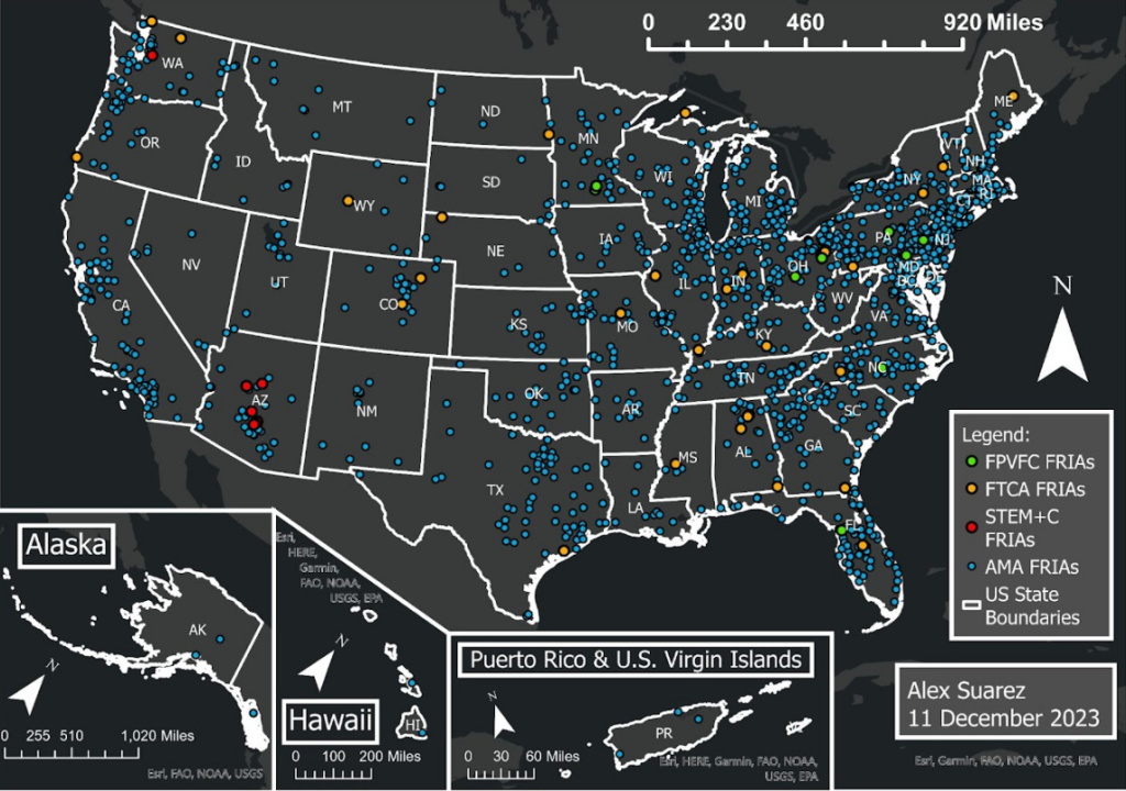
How to Use FAA Maps to Find FRIAs
The FAA has made it straightforward to find FRIAs through its online mapping tools. Below are the steps to access and navigate these maps:
- FAA UAS Data Delivery Service (UDDS) Map:
- Navigate to the FAA UDDS Map.
- This interactive map provides a comprehensive view of FRIAs across the country. Users can zoom in and out to locate FRIAs in their area of interest. Clicking on a specific FRIA will reveal detailed information about its boundaries, the entity that established it, and other relevant data.
- ArcGIS FRIA Map:
- Visit the ArcGIS FRIA Map.
- Similar to the FAA UDDS Map, this resource offers an intuitive interface for users to explore existing FRIAs. The map features tools for searching and filtering FRIAs based on specific criteria, making it easier to find areas that meet your needs.
Utilizing Maps for Educational Purposes
These mapping tools are useful for locating FRIAs and serve as educational resources in themselves. Teachers and students can use these maps to study the geographic distribution of FRIAs, understand the criteria for their establishment, and explore the relationship between drone flying areas and surrounding airspace restrictions. This practical application of drone regulations and geographic information systems (GIS) technology can enhance STEM education by providing real-world examples of how aviation and technology intersect with regulatory frameworks.
Flying Within FRIAs
When operating a drone within a FRIA, adhering to the designated geographical boundaries is imperative. Both the drone and the control station must remain within the confines of the FRIA, and drone flight must always be within the operator’s visual line of sight. Although drones equipped with Remote ID technology can fly within FRIAs, they cannot disable their Remote ID broadcast. This means that such drones will continue to broadcast identification signals even when operating in a FRIA, aligning with the FAA’s commitment to safety and transparency in all drone operations.
Navigating Regulatory Compliance
Understanding and navigating the regulatory landscape of drone operations can be daunting for educational institutions. However, the establishment of FRIAs offers a pathway to compliance, allowing schools to leverage drone technology for educational purposes. It is essential for institutions to stay informed about the latest FAA regulations and guidance to ensure a safe and compliant drone program.
For further guidance on the FRIA application, read Advisory Circular 89-3.
For additional information on FRIA, read 14 CFR Part 89.
Essential Resources for Drone Operators and Educators
To navigate the complexities of drone operation within educational settings and beyond, it’s crucial to have access to authoritative resources. These resources guide compliance with current regulations and ensure safe and responsible drone use. Below is a list of essential readings and tools every drone operator and educator should be familiar with:
- Title 14 CFR Part 89, Remote Identification of Unmanned Aircraft: This section of the Code of Federal Regulations establishes the requirements for the remote identification of drones, providing essential information for understanding how drones are identified in U.S. airspace. Read more.
- Title 14 CFR Part 107, Small Unmanned Aircraft Systems: This regulation covers operating and certifying small unmanned aircraft systems (UAS) within the United States. It’s a critical read for anyone operating drones for commercial purposes or within educational institutions. Read more.
- Title 49 of the United States Code (49 U.S.C.) § 44809, Exception for Limited Recreational Operations of Unmanned Aircraft: This section provides guidelines and exceptions for the recreational use of drones, highlighting the balance between enjoyment and safety in drone operation. Read more.
- AC 91-57, Exception for Limited Recreational Operations of Unmanned Aircraft: This advisory circular provides guidance for the recreational flying of drones, ensuring that hobbyists comply with national airspace regulations. Read more.
- AC 107-2, Small Unmanned Aircraft Systems (Small UAS): This advisory circular offers an in-depth look at the rules governing the commercial use of small UAS, including operational limitations and pilot certification. Read more.
- FAA Order 1050.1, Environmental Impacts: Policies and Procedures: This order details the FAA’s policies and procedures for considering environmental impacts in its decision-making process, including the operation of drones. Read more.
- Aeronautical Information Manual (AIM): The AIM provides the aviation community with comprehensive information on the national airspace system, offering insights into safe and efficient airspace use by manned and unmanned aircraft. Read more.
- Temporary Flight Restriction (TFR) listing: This resource lists all current TFRs, which are temporary restrictions on certain areas of airspace. Understanding TFRs is crucial for drone operators to avoid unauthorized airspace entry. Check current TFRs.
- Aeronautical Navigation Products (Charts): These charts provide detailed information on airspace, aiding drone operators in planning flights that comply with regulations and avoid restricted areas. Explore charts.
- Notices to Air Missions (NOTAM): NOTAMs provide timely information on airspace changes that could affect drone operations, including temporary restrictions and hazards. Check current NOTAMs.
By familiarizing themselves with these resources, drone operators and educators can ensure that their drone programs are enriching and engaging for students and aligned with national standards for safety and airspace compliance.
The Future of Drones in Education
As drone technology continues to evolve, its potential in educational settings is boundless. From enhancing STEM education to providing unique perspectives in fields such as geography, environmental science, and photography, drones offer an engaging tool for learning. By understanding and adhering to Remote ID requirements and utilizing FRIAs, educational institutions can safely and effectively integrate drones into their curriculum, preparing students for the technological landscape of the future.
Shop More Products
From classroom-friendly kits to hands-on tools: Explore our hardware, packages, and accessories tailored for the educational journey.